There are many advantages to life in the Blue Mountains, but bushfires have repeatedly extracted a heavy toll on residents.
If you live in Mt Riverview then sooner or later you too will be affected by bushfires. It’s simply a case of ‘when’ not ‘if’.
That’s why it’s vital to prepare a bushfire survival plan as part of the recommended Prepare Act and Survive strategy for all mountains residents.
But just how likely are Mt Riverview residents to be in the path of a major blaze?
If you’ve settled in Mt Riverview since the last major bushfire impacted the area then ask a long term resident. Few areas of the Blue Mountains have been spared large scale destruction of bushland. Many residential areas have also been hit – including some adjacent to Mt Riverview.
Catastrophic bushfires have struck the Blue Mountains roughly each decade for the last half century. Homes in Mt Riverview were last threatened by a major blaze in 2013, but the mega-blazes of 2019-20 threatened catastrophe from three sides.
Here’s the time line of major blazes in living memory which have blackened large tracts of Blue Mountains bushland, destroyed homes and in some cases claimed lives.
| 1915/16 | 1944/45 | 1982/83 | 2019/20 |
| 1926/27 | 1951/52 | 1994/95 | |
| 1936/37 | 1957/58 | 2001/02 | |
| 1939/40 | 1968/69 | 2006/07 | |
| 1944/45 | 1977/78 | 2013 |
Many of these fires did their damage well away from Mt Riverview, but others were uncomfortably close.
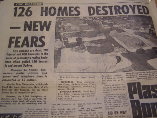
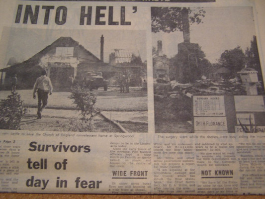
In 1957 a large October fire burnt from the Blaxland Tip towards the Mt Riverview ridge. Three months later theblackened bush from that fire protected Mt Riverview by stopping a much larger blaze which had destroyed 180 homes further up the mountains. Even so, the flames reached Boorea Street.
The bushfires of 1968 dwarfed all others in the mountains before or since. Forty homes at Blaxland were burnt to the ground by a blaze which had its origins at Bilpin in September, moved across to North Springwood in October, headed into the Grose Valley in November then came out again as an inferno which raged down the mountains.
Once again Mt Riverview was largely spared – an August fire in Dawn Crescent created a fire break which mostly saved the township of Mt Riverview, although six homes in Bellerive Street and Rusden Road were lost. It wasin 1968 the Mt Riverview brigade was formed.
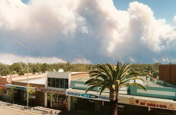
In more recent times the Christmas fires of 2001 brought smoke and flames even closer (on both sides of Old Bathurst Road then right into Mt Riverview with major outbreaks in the valleys of Fitzgerald Creek and Cripple Creek).
The blaze burnt in difficult terrain while fire crews worked at back burning to put in a containment line behind houses in Grand View Drive. With resources stretched by multiple outbreaks throughout the Blue Mountains, the outcome was in doubt for many hours.
Spared again, local residents could only thank their luck and think of the seven families in Cross Street Warrimoo who lost their homes on that same day.
In 2013 a major October blaze, which became known as the State Mine Fire, started near Lithgow and a day later in deteriorating weather conditions a second outbreak – the Linksview Fire – took hold at Springwood.
In terms of burnt area, the State Mine fire was easily the larger blaze, but the Linksview fire quickly created far more havoc, in hot and windy weather, destroying almost 200 houses around Springwood, Winmalee and Yellow Rock. Residents at the northern end of Mt Riverview watched in trepidation as a rolling wall of smoke and flame approached them that Thursday. More than half the residents of Grand View Drive abandoned their homes and a small team of RFS volunteers prepared to defend properties in what would have been a very unequal fight.
Somehow Mt Riverview dodged a bullet that afternoon. As the unstoppable inferno raced from Yellow Rock towards Cripple Creek and Fitzgerald’s Creek there was a sudden wind change. The flames roared their way through the bush to the creeks’ northern banks but the wind change then carried the blaze to the east, across the Nepean River where less fuel made it easier to defeat.
Local and interstate fire units carried out a major backburn on Mt Riverview’s north and north western flanks in the days that followed, sparing our residents from further fire danger, at least until the next outbreak.
The 2019/20 fire season in New South Wales was the worst in the history of European settlement here, with 34 lives lost, 5.4 million hectares burnt and over 6,500 buildings destroyed, including more than 2,900 homes.
Three major fires threatened the Blue Mountains for weeks – the Gospers Mountain fire burned 512,626 hectares, the Erskine Creek fire burnt 22,631 hectares and the Green Wattle Creek fire took out 278,199 hectares.
More than 20 houses and buildings were lost in Bell and Bilpin and fire fighting resources were pushed to the limit defending communities throughout the mountains. By the time the blazes were declared out they had burnt nearly 80 per cent of the World Heritage area.
Then and now
Much has changed in the Blue Mountains in the last 50 years to alter the potential threat of bushfires – to alter but by no means eliminate the threat. On the positive side, mains water supplies are now available in built up areas and the resources of the Rural Fire Service and NSW Fire and Rescue have been steadily bolstered.
On the other hand many more residents now live on the front line – the bush interface – where homes are at risk of direct impact by fire as well as massive ember attack which can also lead to their destruction.
What to expect
When a major bushfire event strikes the Blue Mountains, residents of Mt Riverview should prepare for impacts which will vary depending on where the fire is.
Smoke and diminished air quality will be among the first effects you may notice, but also plan for the possibility of reduced water pressure and allow for traffic congestion on Old Bathurst Road and the Great Western Highway.
If fire is burning widely through the Blue Mountains it is also possible that blackouts may occur and that mobile phone services will become congested and may fail.
As a general rule, bushfires create their greatest havoc on northwest facing slopes and areas adjacent to them. Unfortunately bushfires also tend to ignore general rules. The fires which have posed the most risk to Mt Riverview residents have approached from the Northwest.
Who will protect your home?
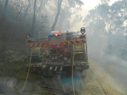
The Blue Mountains is well resourced with 26 brigades of the Rural Fire Service (the world’s largest volunteer fire service) and your Mt Riverview brigade is equipped with two tankers, one category 1, and one category 7, but the sheer scale of major bushfires can make for an uneven contest.
Such blazes often threaten several areas at the same time and it just isn’t possible to have tankers protecting property in every street – even with reinforcements from NSW Fire and Rescue and interstate services.
In a major outbreak local brigades might already be committed elsewhere when the fire impacts this area. You should take this fact into consideration when deciding to leave early or to stay and defend your property.
Prepare, Act and Survive
Don’t wait until a bush fire approaches before making your plans. Now is the time to make decisions which could be critical to surviving a major blaze.
For more information call the Bush Fire Information Line on 1800 679 737 or visit www.rfs.nsw.gov.au